
King George Island, Antarctica: The Airstrip, the Bases and the Church
King George Island explained: the gravel airstrip, the research stations by country, Trinity Church, what you can photograph, the time zone.
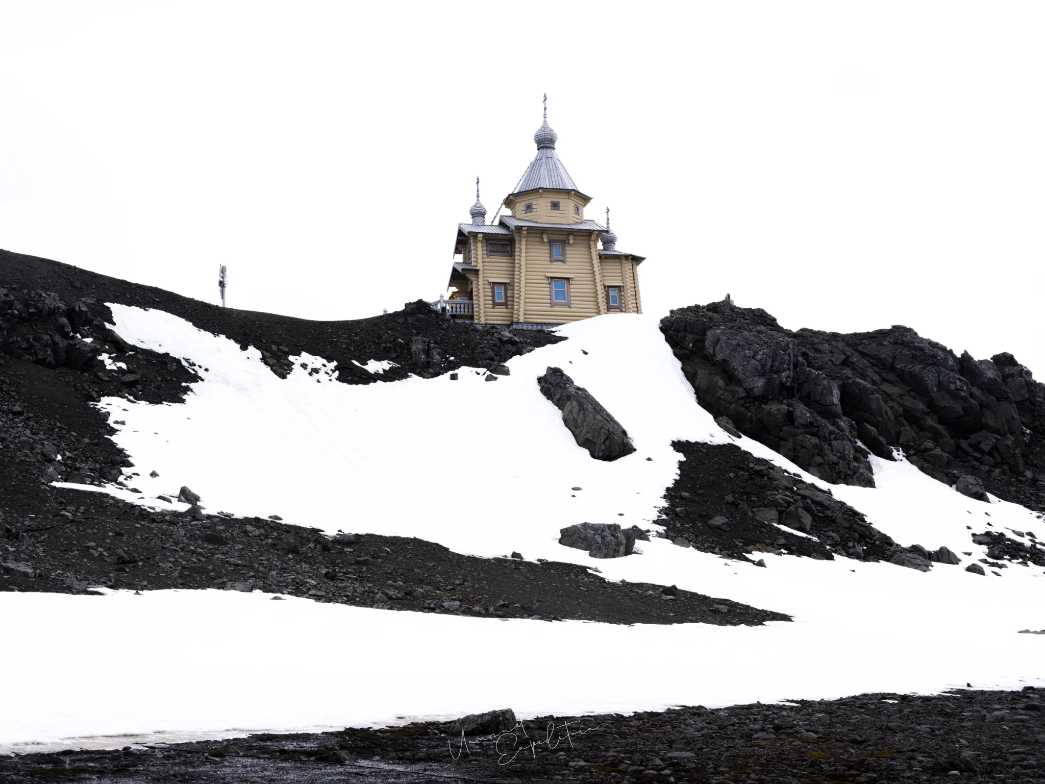
King George Island is the largest of the South Shetland Islands, about 120 km north of the Antarctic Peninsula at roughly 62 degrees south, and it holds the densest cluster of research stations anywhere in Antarctica. It has a gravel airstrip on the Fildes Peninsula, a Russian Orthodox church built of Siberian timber, and a bay where small expedition ships wait for their guests. For most people who fly to Antarctica, King George Island is the first ground they stand on.
On our March departure it is where the charter flight from Punta Arenas lands and where we board the ship, so the island opens the voyage described in the complete guide to an Antarctica photography tour. Here is the island itself: the airstrip, the bases, the church, what you can and cannot point a camera at, and the time zone question that comes up in almost every enquiry.
Does King George Island have an airport?
Yes. King George Island has the Teniente Rodolfo Marsh airfield, a gravel runway on the Fildes Peninsula beside Chile's Presidente Eduardo Frei base. It is an airfield in the working sense, not an airport in the passenger sense; passengers walk from the aircraft across the gravel. The aircraft that use it are the BAe 146 and Avro RJ family, four-engine high-wing jets that handle unpaved strips well. The field has no instrument landing system, so pilots need line of sight to land, and that single fact shapes every fly-cruise schedule in Antarctica. Operators' published statistics put roughly four in five Punta Arenas to King George Island flights on their scheduled day and most of the rest within a day. How that contingency works, including the hotel and meal cover while you wait, is explained in how an Antarctica fly cruise works.
How to get to King George Island
There are two practical ways for a visitor to reach King George Island. The first is by ship from Ushuaia in Argentina or Punta Arenas in Chile, crossing the Drake Passage, which takes 36 to 48 hours each way. The second is the charter flight from Punta Arenas, about two hours, which is how our group arrives. Antarctica21, the Punta Arenas operator who runs our air-cruise and has been flying fly-cruises since 2003, charters the aircraft and holds the permits. There is no scheduled commercial service; tourists travel under an operator's authorisation, as the Antarctic Treaty system and IAATO rules require. From Singapore the journey starts with a long-haul routing to Santiago and then a domestic flight to Punta Arenas, which our article on getting to Antarctica from Singapore covers in detail.
Which research stations are on King George Island?
The Fildes Peninsula alone has stations from four countries within walking distance of each other. The table lists the main stations and the country that runs each one.
| Station | Country | Note |
|---|---|---|
| Presidente Eduardo Frei | Chile | Beside the Teniente Marsh airfield on the Fildes Peninsula |
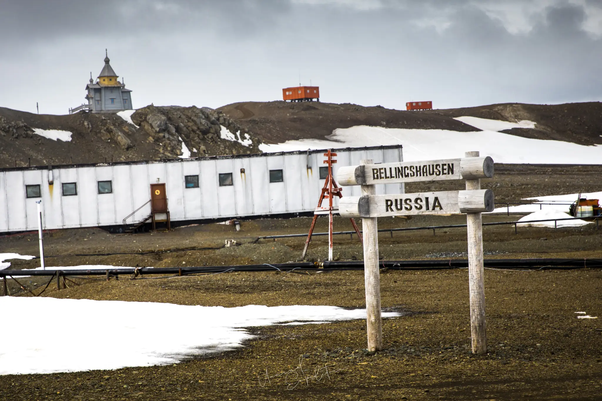
| Bellingshausen | Russia | Trinity Church stands on the rise above it |
| Great Wall | China | Nearby on the Fildes Peninsula |
| Artigas | Uruguay | Nearby on the Fildes Peninsula |
| Other stations on the island | Argentina, Brazil, Poland, South Korea, Peru among them | Spread around the island's coast |
No single country runs King George Island; the Antarctic Treaty of 1959 froze all territorial claims, so the stations sit side by side as scientific workplaces, not as outposts of anyone's territory.
King George Island church: Trinity Church above Bellingshausen
The King George Island church that people search for is Trinity Church, a Russian Orthodox church on a rise above Bellingshausen station. It was built of Siberian timber in Russia, taken apart, shipped south and reassembled on the island, and it was consecrated in 2004. It holds 20 to 30 people and is the southernmost Orthodox church in the world. Photographically it is the one man-made subject on the Fildes Peninsula that looks like it belongs in a picture: dark timber, a small onion dome, and behind it the grey bay or the snow slopes. A 24-70mm lens handles the exterior; a 16-35mm lens is useful if you are invited inside and the light allows. Treat the exterior as the photograph you can plan for and the interior as a gift if it happens.
What can a visitor photograph on King George Island?
On the Fildes Peninsula a visitor can photograph the airfield and the aircraft on the gravel, the exterior of the research stations, Trinity Church, the shoreline of Fildes Bay (also called Maxwell Bay) with the ship at anchor, and the Zodiacs running between the beach and the ship. Research stations are workplaces, and visitors are not guaranteed access inside any of them; some stations welcome a short visit when staff are free, others do not, and it is not something the operator can promise. Wildlife on this stretch of coast is sparse compared with the peninsula, but skuas, kelp gulls and the occasional seal on the beach appear. Under IAATO rules, keep at least 5 metres from any animal and more if it reacts, and leave recreational drones in your bag; they are not permitted in coastal wildlife areas. The light is often flat and grey, which suits the stations and the dark timber of the church; expose for the buildings and let the sky go pale.
What time zone is King George Island on?
King George Island itself has no official time zone; Antarctica has none. In practice each station keeps the time of its home country or of its supply base. Chile's Presidente Frei base, the airfield and the Antarctica21 operation all run on Chile's Magallanes time, which is UTC-3 all year, the same as Punta Arenas. Our ship keeps that time throughout the voyage, and Ushuaia, where the voyage ends, is also on UTC-3. For a traveller from Singapore, which is UTC+8, the island is eleven hours behind home, which is one reason we insist on arriving in Punta Arenas at least one night early.
What is the weather like on King George Island in March?
King George Island in March sits at the end of the Antarctic tourist season, which runs from late October to late March. Temperatures hover around freezing, roughly minus 5 to plus 3 degrees, with wind chill much lower on the exposed peninsula. The weather changes fast, snow showers come through, and low cloud on the Fildes Peninsula is the thing everyone watches because the flight depends on it. Daylight in mid March is roughly thirteen hours, with sunrise around breakfast and sunset in mid evening, so there is a real golden hour at each end of the day for the first time since the midsummer months. Dress for the beach landing as for a Zodiac day: waterproof trousers, the supplied expedition boots, gloves you can work a camera in. The packing list for an Antarctica cruise goes through the layers.
"In December 2019 we flew in with Antarctica21, and the first thing anyone did on the gravel was stand still and stare at rock, because two hours earlier we had been in Punta Arenas. King George Island is not pretty in the way the peninsula is pretty. It is gravel, fuel drums and huts in national colours, and a church that looks like it was dropped there from the Urals. I liked it for exactly that reason. It is the one place on the trip where you photograph people living in Antarctica."
Joseph Mak, tour leader, Unusual Expedition
How King George Island fits our fly-cruise
On the Antarctica Express Air-Cruise, King George Island is the hinge of the trip. The group gathers in Punta Arenas for the briefing and boot fitting, flies to the Teniente Marsh airfield when the weather window opens, walks to the shore of Fildes Bay and boards the ship by Zodiac. From there the ship works the South Shetlands and the Antarctic Peninsula as ice and weather allow, then crosses the Drake Passage once, northbound, towards Cape Horn and Ushuaia. The time ashore is short and depends on the flight and the ship, so I do not plan photographs around it; I have the camera out with a 24-70mm lens on and take what the island offers. After four midsummer voyages, one of them an Antarctica21 air-cruise in December 2019, we chose the fly-cruise for March because the one-way Drake and the late-season light suited photographers better; the island is the price of admission, and a reasonable one.
Stand on the gravel with us
If you want to see King George Island, the stations and Trinity Church, and then spend the real days of the voyage among icebergs, penguins and whales on the Antarctic Peninsula, our Antarctica photography tour page has the current departure and how to book. I will be on the gravel with you, camera out, and in the Zodiac after that.
Join the Antarctica photography tour
Antarctica Express Air-Cruise 2028 - Antarctica departs 10 Mar 2028 To 16 Mar 2028. Small group, photography first. All Antarctica photography tours.
Explore Antarctica in depth
- The Complete Guide to an Antarctica Photography TourAntarctica
- King George Island: Weather by Month, Daylight Hours and PenguinsAntarctica
- Sunset in Antarctica: Does the Sun Set, and What the Light DoesAntarctica
- Antarctica Photos: What It Really Looks Like from an Expedition ShipAntarctica
- What to Pack for an Antarctica Cruise (and the 25 kg Rule)Antarctica
- Photographing the South Shetland IslandsAntarctica
- Is Antarctica Worth Visiting? A Photographer's ViewAntarctica
- Crossing the Drake Passage: What to ExpectAntarctica
- Cape Horn and the Beagle Channel: Photographing the End of the WorldAntarctica
- Camera Gear for Antarctica PhotographyAntarctica
- The Best Time to Visit Antarctica for PhotographyAntarctica
- Photographing Whales in AntarcticaAntarctica
Upcoming Photo Tours
- Egypt Photo Tour – EgyptEgypt 12 Dec 2026 To 20 Dec 2026
- Inner Mongolia Winter Owl Photo Tour – ChinaChina 01 Jan 2027 To 04 Jan 2027
- Inner Mongolia Winter Photo Tour – ChinaChina 05 Jan 2027 To 11 Jan 2027
- Mekong And Central Highland Vietnam Photo Tour - VietnamVietnam 16 Jan 2027 To 24 Jan 2027