
Photographing the South Shetland Islands
The South Shetland Islands for photographers: the Treaty area, Deception Island black sand, Half Moon chinstraps, wildlife and March light.
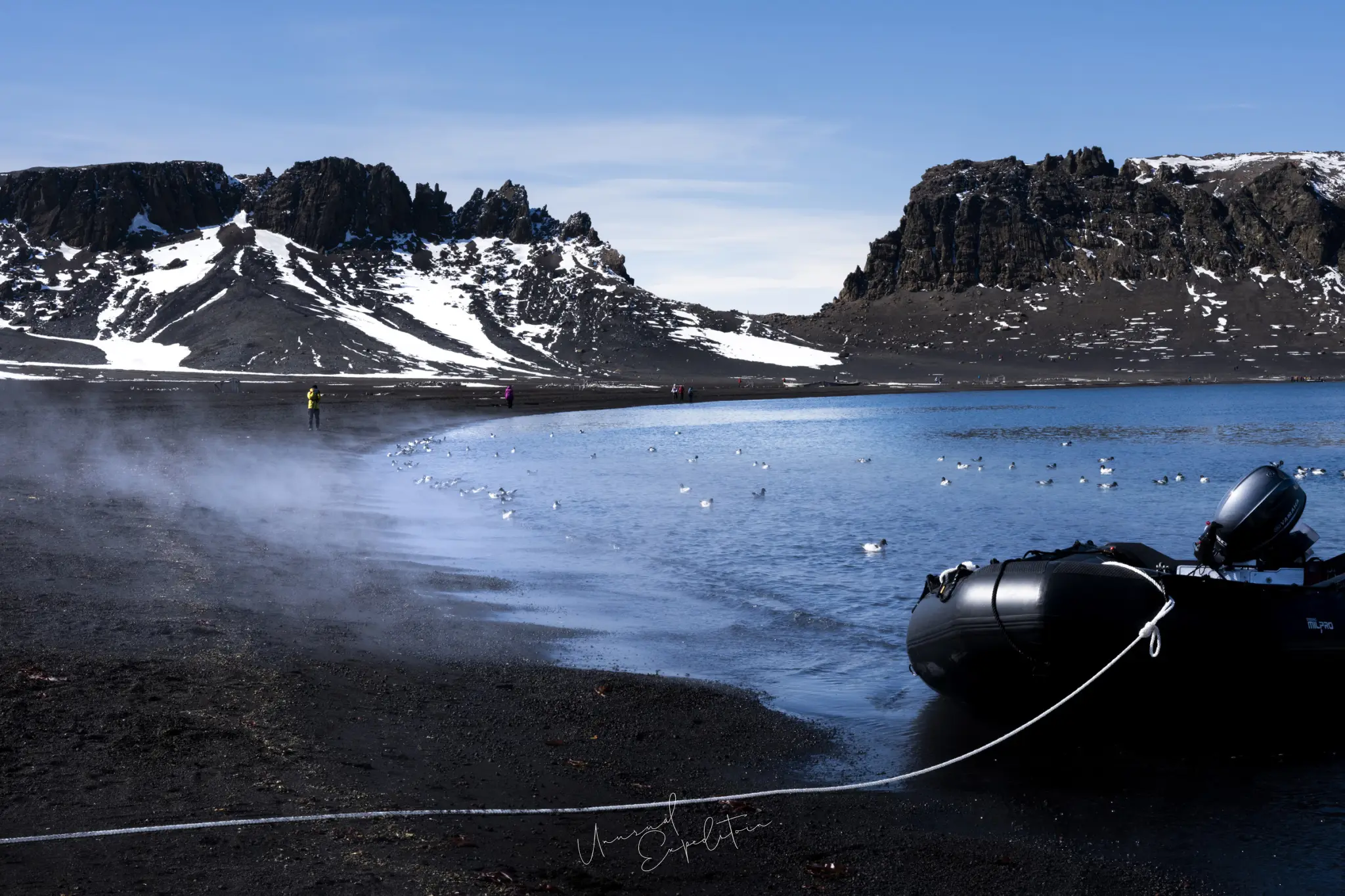
The South Shetland Islands are an arc of islands about 500 km long lying off the northern tip of the Antarctic Peninsula, inside the Antarctic Treaty area, and they are where most Antarctic voyages, including our fly-cruise, first meet ice, penguins and black volcanic sand. For a photographer they offer chinstrap colonies on the scale of a town, a flooded volcano you can sail into, and the contrast of dark beach against white snow that the peninsula further south rarely gives.
The islands are one of the two regions our ship works between King George Island and the Drake Passage, and they sit inside the wider picture in the complete guide to an Antarctica photography tour. What follows is the standard geography, the named islands, the wildlife, and how I photograph the place; which islands the ship reaches is decided by ice and weather on the day.
Are the South Shetland Islands part of Antarctica?
Yes, for every practical purpose. The South Shetland Islands lie south of 60 degrees south, which puts them inside the area governed by the Antarctic Treaty of 1959, in force since 1961. The Treaty froze all territorial claims, so nobody owns the South Shetlands; several countries maintain claims on paper and research stations on the ground, and none of those claims has legal effect while the Treaty stands. There is no border, no customs post and no visa. Visitors arrive under an operator's permit, and tourism is run under the rules of IAATO, the International Association of Antarctica Tour Operators, founded in 1991. Geologically and biologically the islands are Antarctic too: glaciated, with penguin colonies and seal haul-outs, in Southern Ocean water. A trip that visits only the South Shetlands counts as going to Antarctica, though our voyage continues south to the peninsula as well.
Where the South Shetland Islands are
The South Shetland Islands run roughly parallel to the Antarctic Peninsula, separated from it by the Bransfield Strait and sitting about 120 km north of the peninsula coast at the King George Island end. The arc stretches about 500 km from Elephant Island in the northeast towards the peninsula's tip in the southwest. North of the islands is the Drake Passage and the open Southern Ocean; the islands are the first land a ship from Cape Horn meets, and on our route they are the last land before the ship turns north for the one-way crossing described in crossing the Drake Passage. King George Island, the largest, holds the airstrip and research stations covered in our article on King George Island. Livingston Island is the second largest.
The named South Shetland Islands people search for
Four islands come up again and again in searches, and each has a reason.
| Island | What it is known for | Photographic interest |
|---|---|---|
| King George Island | Largest island; airstrip, research stations, Trinity Church | Human presence in Antarctica, the church, the ship at anchor |
| Livingston Island | Second largest island | Glaciers to the shore, beaches with seals |
| Deception Island | Flooded volcanic caldera; Whalers Bay with black sand | Black sand against snow, steam, old whaling station remains |
| Half Moon Island | Chinstrap penguin colony | Chinstraps on rock with glaciated Livingston Island behind |
| Elephant Island | Where Shackleton's men waited for rescue in 1916 | History more than pictures; landings are rare and the coast is exposed |
The table is a list of places, not a route; an expedition ship might reach two or three of these on a voyage, and which ones depends entirely on sea state and ice.
Deception Island: black sand and snow
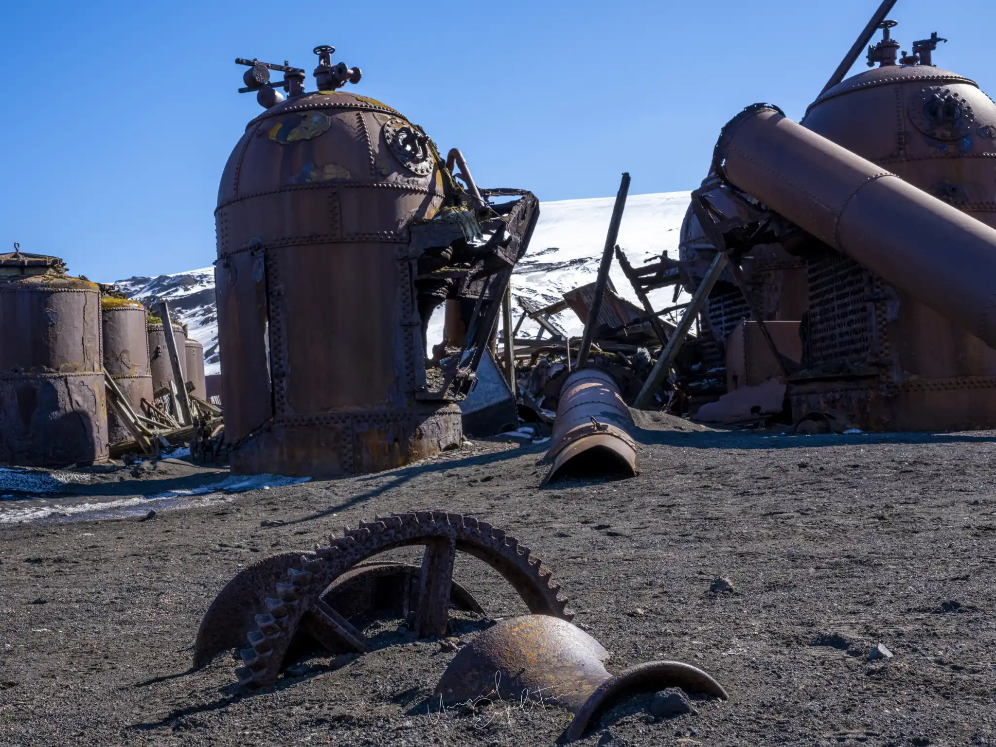
Deception Island is a volcano whose caldera has flooded, so a ship can sail through a narrow gap in the crater wall into a sheltered inner bay. Whalers Bay inside the caldera has a beach of black volcanic sand with the remains of an old whaling station along it, and in places the ground is warm enough that steam rises from the waterline. For a photographer the subject is contrast: snow on black sand gives a frame with true black and true white in it, which is rare in Antarctica. A 24-70mm lens handles the beach and the rusted tanks; a 70-200mm lens picks out the line where snow meets sand and the penguins or seals standing on it. Expose for the snow, not the sand, or the whole frame goes muddy. It is one of my favourite Antarctic subjects, and it photographs as well in flat light as in sun.
Whalers Bay
Whalers Bay is the beach inside Deception Island's caldera where ships anchor and Zodiacs land, and it is the most photographed stretch of the South Shetland Islands. The sand is black volcanic ash, warm enough in places for steam to rise where meltwater runs across it, and along the shore stand the rusting boilers and tanks of a Norwegian whaling station abandoned in 1931, the collapsed hangar of a later British base, and the wooden ribs of old water boats half buried in ash. Fur seals and the odd gentoo use the beach; chinstraps nest on the outer coast at Baily Head rather than inside. Photographically the bay is about contrast: black sand, white snow on the crater rim, rust-red iron, and fog that comes and goes through the entrance. A 24-70mm lens covers the station; a wide lens from the slope above takes in the whole bay with the ship small in the middle of it.
South Shetland Islands wildlife
The South Shetland Islands wildlife list is the Antarctic Peninsula list with a few local emphases. Chinstrap penguins are the signature bird, with colonies at Half Moon Island and Baily Head on Deception Island; gentoos are common and Adelies appear at some sites, though by March the Adelie colonies have largely emptied. Antarctic fur seals haul out on the beaches in numbers in late season, along with Weddell seals, the occasional leopard seal on an ice floe, and southern elephant seals lying in heaps. Humpback and minke whales feed in the Bransfield Strait and around the islands, and orca pass through. Overhead and offshore are southern giant petrels, cape petrels, Wilson's storm petrels, skuas, kelp gulls, snowy sheathbills, Antarctic terns and Antarctic shags. There are no land predators, so none of these animals flee people; the IAATO rule of at least 5 metres, more if an animal reacts, protects them, not you. Species by species detail is in seals and seabirds of Antarctica.
Photographing the chinstrap colonies
A chinstrap colony in the South Shetland Islands is loud, crowded and busy from the first minute you land, and the mistake most people make is to photograph the crowd. Pick two birds. Chinstraps greet each other with heads thrown back and flippers out, and a pair doing that against a clean background beats two hundred birds against a slope. Get down to their eye level, which means kneeling in the mud or snow where the guides say kneeling does no harm, and use a 70-200mm lens from 5 metres so the bird fills the frame without you moving closer. In March the chicks are fledging and the adults are moulting, so expect scruffy birds standing very still and well-grown chicks chasing adults for food; shutter speeds of 1/1000 s cover the chases, and 1/2000 s or faster for birds leaping out of the water onto the rocks. The penguin photography article covers the three species on this route in detail.
"At Half Moon Island on one of my midsummer voyages the light went flat and everyone put their cameras away. I stayed on my knees in the snow with two chinstraps that were calling to each other, heads back, and the grey sky turned the whole scene into a pencil drawing. That picture is still the one people ask about. The colony was the setting; the pair was the photograph."
Joseph Mak, tour leader, Unusual Expedition
Light and weather in the South Shetland Islands in March
The South Shetland Islands sit at about 62 degrees south, and in mid March they get roughly thirteen hours of daylight, with sunrise around breakfast, sunset in mid evening and long twilights at both ends. That is the main reason we chose March after four midsummer voyages, when the sun barely set and the light was flat for most of the day. Temperatures sit around freezing, roughly minus 5 to plus 3 degrees, with wind chill much lower in the Bransfield Strait. Weather changes within an hour, snow showers pass through, and fog is common where the cold Southern Ocean water meets the islands. None of that is bad for pictures: fog isolates a colony, snow puts texture into a grey sky, and late sun comes in low and gold across the black beaches. Exposure in these conditions is covered in our Antarctica exposure tips for snow and ice.
South Shetland Islands weather by month
The South Shetland Islands weather by month changes less in temperature than people expect and more in light and snow cover. These are long-run averages for the coastal stations on King George Island, rounded; the exposed outer islands are windier.
| Month | Mean temperature | Daylight | What it means ashore |
|---|---|---|---|
| November | About minus 2 to minus 1 degrees | About 17 to 19 hours | Snow to the beach, penguins on nests, icebergs largest |
| December | About 0 to plus 1 degrees | About 20 hours, no real night | Chicks hatching, most ships, flat midsummer light |
| January | About plus 1 to plus 2 degrees | About 19 hours | Warmest month, muddy colonies, sleet possible |
| February | About plus 1 to plus 2 degrees | About 15 to 16 hours | Fledging, whales numerous, sunsets return, fog |
| March | About 0 to plus 1 degrees | About 12 to 13 hours | Our month: real sunsets, moult, fewer ships, first autumn snow |
Overcast is the normal sky in every month, so plan for flat light and treat a clear day as the bonus it is. The month-by-month detail for the island where the flight lands is in King George Island weather by month.
What a landing in the South Shetlands is like
A landing in the South Shetland Islands begins in the Zodiac, with the camera sealed in a dry bag until you are ashore. Under IAATO rules no more than 100 visitors are ashore at one site at a time with a guide for every 20 guests, so the group spreads out along flagged routes that keep people away from nesting birds. Boots and outer gear are biosecurity-checked before every landing, which means vacuuming pockets and Velcro so no seeds move between islands. Decide early what the picture is and work it, because the Zodiacs go back when the expedition leader says so. Landings are attempted, not promised; a swell on an exposed beach cancels one without discussion. Keep a lens cloth in an outer pocket for spray and the spare battery in an inner one for warmth.
Sail into the caldera with us
The South Shetland Islands are the opening act of the Antarctic Peninsula, and on our fly-cruise they are where the ship's work begins. If chinstraps on black sand and a flooded volcano sound like your kind of subject, the Antarctica photography tour page has the current March departure. Bring waterproof trousers you can kneel in; you will find me on my knees in the snow beside you.
Join the Antarctica photography tour
Antarctica Express Air-Cruise 2028 - Antarctica departs 10 Mar 2028 To 16 Mar 2028. Small group, photography first. All Antarctica photography tours.
Explore Antarctica in depth
- The Complete Guide to an Antarctica Photography TourAntarctica
- King George Island: Weather by Month, Daylight Hours and PenguinsAntarctica
- Sunset in Antarctica: Does the Sun Set, and What the Light DoesAntarctica
- Antarctica Photos: What It Really Looks Like from an Expedition ShipAntarctica
- What to Pack for an Antarctica Cruise (and the 25 kg Rule)Antarctica
- King George Island, Antarctica: The Airstrip, the Bases and the ChurchAntarctica
- Is Antarctica Worth Visiting? A Photographer's ViewAntarctica
- Crossing the Drake Passage: What to ExpectAntarctica
- Cape Horn and the Beagle Channel: Photographing the End of the WorldAntarctica
- Camera Gear for Antarctica PhotographyAntarctica
- The Best Time to Visit Antarctica for PhotographyAntarctica
- Photographing Whales in AntarcticaAntarctica
Upcoming Photo Tours
- Egypt Photo Tour – EgyptEgypt 12 Dec 2026 To 20 Dec 2026
- Inner Mongolia Winter Owl Photo Tour – ChinaChina 01 Jan 2027 To 04 Jan 2027
- Inner Mongolia Winter Photo Tour – ChinaChina 05 Jan 2027 To 11 Jan 2027
- Mekong And Central Highland Vietnam Photo Tour - VietnamVietnam 16 Jan 2027 To 24 Jan 2027